International
On-line
Positioning
User
Service
IOPUS allows your staff or customers to
submit their GPS data files to your web site, where the data will
be processed to determine a position.
The submitted data file will be processed with respect to three of your or
International GNSS Service
CORS sites. The sites selected may not be the nearest to the data
site but, rather, are selected by distance, number of observations,
site stability and other indicators that the site will contribute
to a high-quality solution.
The position for submitted data will be reported back to the
customer via email in ITRF coordinates as well as UTM northing
and easting.
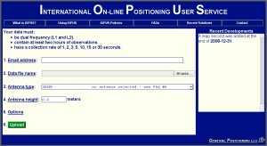
IOPUS is completely automatic and requires
only a minimal amount of information from the user:
- The email address where the user wants the results sent
- The data file that the user wants to process (which he or she
may select using a browse feature).
- The antenna type used to collect this data file
(selected from a list of calibrated GPS antennas).
- The height of the Antenna Reference Point (ARP)
above the monument or mark that the user is positioning.
- As an option, the user may select up to three base stations to be used
in determining their solution.
Once this information is complete, a click of
the Upload button sends the user's data to your website.
The results will be emailed
back to the user, usually within a few minutes.
The user can even upload multiple data files
in a zip archive if desired.
IOPUS is considered a research tool.
Its results are provided "as is" without any guarantee, and the
results are not sanctioned by any civil, state or federal authority.
IOPUS
is a complete system:
hardware, software, installation, setup with customization and
internationalization, and training.
You need to provide an appropriate environment for
the hardware, suitably reliable power and internet access, and a point of
contact for the minimal on-site maintenance of the equipment.
|